We had a new page that set our program against PVGIS.
On it, the program calculated the yield for forty-three places around the world and set it next to what PVGIS says - the European Commission’s calculator, the one everyone in this field measures themselves against. Each place was a coloured dot: green if we agreed, yellow if we drifted a little, red if we drifted a lot.
Among the red dots, two stood out, and both were in the Alps. At Chamonix we promised 11.7% more sun than PVGIS. At Névache, a village in a valley of the French Alps, 14.4% more.
The first suspicion fell, as usual, on the sky. Our data on how cloudy a place is comes from satellites, and satellites have their bad days over mountains, where snow and cloud look very much alike from above. But the suspicion could be checked. PVGIS has an option that tells it to ignore the surrounding mountains. We switched it on, and at Chamonix PVGIS jumped 7.5% upwards, almost to our figure. The sky was fine. The mountains were missing.
Not that we had no mountains at all. We had an elevation map with one point every tenth of a degree - about eleven kilometres apart. A valley two kilometres wide, between two walls a thousand metres high, does not fit in a map like that. The walls melt into the average of the cell, and what remains looks like a gentle hill seen from far away. The winter sun, which at Chamonix barely clears the ridges, sailed happily over that hill.
We tried the short way first: we multiplied the relief by three. The flattened mountains grew a little taller, and we recovered fewer than three of the twelve points that were missing. Sometimes a bad solution is useful precisely because it shows, quickly and unambiguously, how far you are from a good one.
The good solution needed finer data. We found an elevation map with a point every ninety metres, published free and without an account, and wrote a program that, for every patch of ground, looks in twenty-four directions and works out how high the land rises towards the horizon. It accounts for the curvature of the Earth, which lowers distant mountains, and for the way air bends light slightly near the horizon. The result is, for every place, a silhouette: the line the Sun has to clear before it reaches the panels.
The planet has plenty of mountains, but it has far more flat ground, and on flat ground the horizon does not matter. So we cut the globe into one-degree squares and computed silhouettes only where the ground has relief. Five or six thousand squares in all, about three hundred megabytes. A visitor usually downloads just one, around fifty kilobytes, and a small map of one kilobyte tells them in advance which squares exist, so that a house on the Bărăgan plain never asks for a mountain that is not there.
The result came the same day. At Chamonix the difference went from +11.7% to -6.8%. At Névache, from +14.4% to +6%. At Chamonix we went past it: we now promise slightly less sun than PVGIS. For a designer that is the better side to be wrong on, but it is still wrong, and we are not pretending otherwise.
Not every red dot was a mountain. Skjåk, in Norway, read 25% too high, and it would have been tempting to blame the relief for that as well. But the trouble there is different: snow. The satellites mistake it for cloud, and the place looks sunnier than it is. Our new mountains would have fixed nothing, so for now we left it red.
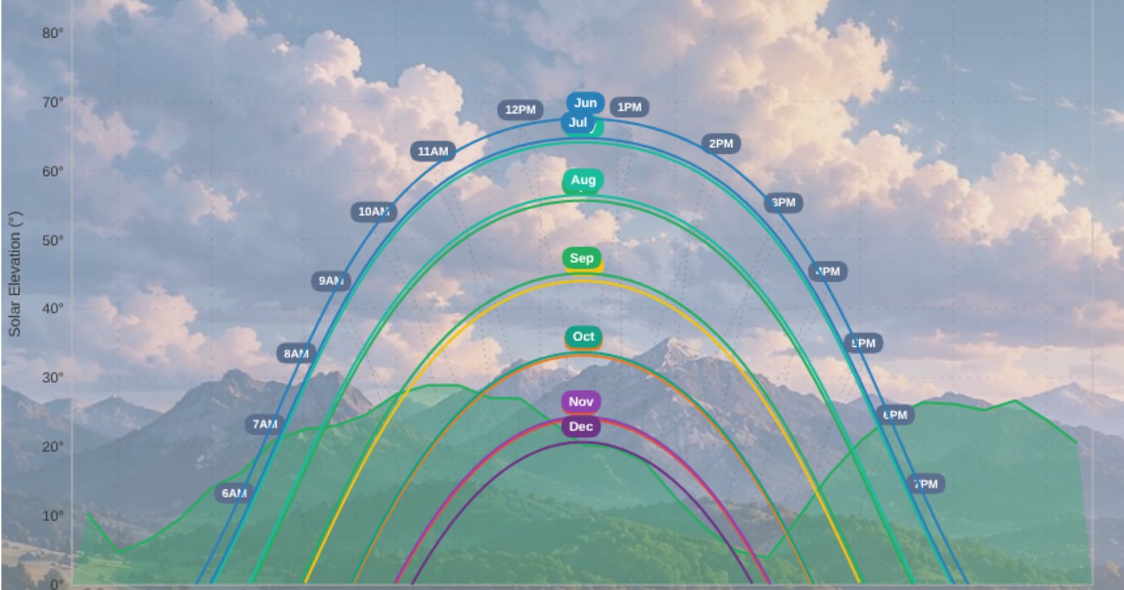
The silhouettes show in the program now. On the sun-path chart, behind the obstacles drawn in red, the outline of the mountains around the house appears in green, and in December you can see exactly where the Sun slips behind the ridge.
In September we went one step further. A silhouette computed for the middle of a one-kilometre cell is wrong exactly where it matters most: on a summit or at the foot of a slope. On Tâmpa, the hill over Brașov, the cell saw a 33-degree wall that, from the top, is not there. Now the horizon is computed for the exact point you picked, from the same ninety-metre data, in one to three seconds.
Until 19 June, our mountains were gentle hills seen from far away. Since then they stand where they belong and do what mountains do: in winter, they hide the Sun earlier than a calculator would expect.